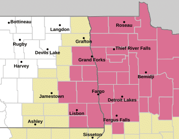
The National Weather Service has issued a Severe Thunderstorm Watch until 9:00 PM this evening (July 6). The watch includes 18 counties in northwest, north central, and central Minnesota, along with eastern North Dakota. A watch means conditions are favorable for severe weather to develop,
Minnesota counties included in the watch are Polk, Red Lake, Pennington, Marshall, Kittson, Norman, Roseau, Mahnomen, Beltrami, Hubbard, Wadena, Lake of the Woods, Becker, Clearwater, Clay, Grant, Ottertail, and Wilkin. North Dakota Counties included in the watch are Grand Forks, Barnes, Cass, Ransom, Richland, Sargeant, Steele, and Traill.
Cities included in the watch, listed in alphabetical order are – Ada, Argyle, Ashby, Bagley, Barrett, Baudette, Bemidji, Breckenridge, Casperson, Clearbrook, Crookston, Detroit Lakes, East Grand Forks, Elbow Lake, Enderlin, Erdahl, Fargo, Fergus Falls, Finley, Grand Forks, Gwinner, Hallock, Halstad, Hatton, Hillsboro, Hope, Karlstad, Lancaster, Lisbon, Long Lost Lake, Mahnomen, Mayville, Menahga, Moorhead, Naytahwaush, Park Rapids, Portland, Red Lake Falls, Roseau, Stephen, Thief River Falls, Twin Valley, Valley City, Wadena, Wahpeton, Warren, Waubun, and Zerkel.