The National Weather Service in Grand Forks, North Dakota, has issued a Blizzard Warning for Crookston and northwest Minnesota from Saturday morning to midnight. The warning includes the Minnesota cities of Crookston, East Grand Forks, Ada, Twin Valley, Halstad, Moorhead, Hallock, Karlstad, Lancaster, Warren, Stephen, Argyle, and Breckenridge. And the North Dakota cities of Grand Forks, Fargo, Lisbon, Enderlin, Gwinner, Milnor, Forman, Rutland, and Wahpeton.
BLIZZARD WARNING IN EFFECT FROM 3 AM SATURDAY TO MIDNIGHT CST SATURDAY NIGHT…
WINTER STORM WATCH NOW IN EFFECT FROM LATE SATURDAY NIGHT THROUGH SUNDAY AFTERNOON…
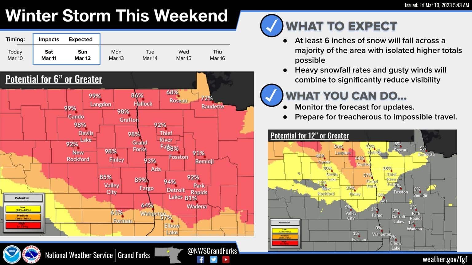
* WHAT...For the Blizzard Warning, blizzard conditions expected. Total snow accumulations of 5 to 9 inches. Winds gusting as high as 45 mph. For the Winter Storm Watch, snow and blowing snow impacts may linger.
* WHERE…Portions of northwest and west central Minnesota and southeast North Dakota.
* WHEN…For the Blizzard Warning, from 3 AM Saturday to midnight CST Saturday night. For the Winter Storm Watch, from late Saturday night through Sunday afternoon.
* IMPACTS…Travel could be very difficult to impossible. Widespread blowing snow could significantly reduce visibility.
* ADDITIONAL DETAILS…The lowest visibilities will occur with heavy snowfall rates. There should be a lull in wind speeds arriving around the time that snowfall rates also decrease during the afternoon or evening Saturday. Northerly winds increase later Saturday night, however lingering impacts are still uncertain late Saturday night into Sunday.
PRECAUTIONARY/PREPAREDNESS ACTIONS...
Travel should be restricted to emergencies only. If you must travel, have a winter survival kit with you. If you get stranded, stay with your vehicle.
Prepare for possible blizzard conditions. Continue to monitor the latest forecasts for updates on this situation.