The National Weather Service in Grand Forks, North Dakota has issued a Blizzard warning for northwest Minnesota and eastern North Dakota. The warning includes the Minnesota cities of Crookston, East Grand Forks, Hallock, Karlstad, Lancaster, Warren, Stephen, and Argyle. The North Dakota cities of Cavalier, Walhalla, Drayton, Pembina, Neche, St. Thomas, Grafton, Park River, Grand Forks, Mayville, Hillsboro, Hatton, and Portland.
WINTER WEATHER ADVISORY NOW IN EFFECT UNTIL MIDNIGHT TONIGHT…
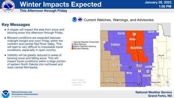
BLIZZARD WARNING IN EFFECT FROM MIDNIGHT TONIGHT TO NOON FRIDAY…
* WHAT…For the Blizzard Warning, blizzard conditions expected. Total snow accumulations of up to two inches. Winds gusting as high as 60 mph. For the Winter Weather Advisory, snow expected. Total snow accumulations of up to one inch. Winds gusting as high as 45 mph.
* WHERE…Portions of the northern and central Red River Valley within northwest Minnesota and eastern North Dakota.
* WHEN…For the Blizzard Warning, from midnight tonight to noon Friday. For the Winter Weather Advisory, until midnight tonight.
* IMPACTS…Very difficult to impossible travel conditions expected. Widespread blowing snow will significantly reduce visibility. The hazardous conditions will impact the Friday morning commute.
* ADDITIONAL DETAILS…Worst conditions will occur in open country outside of sheltered areas.
PRECAUTIONARY/PREPAREDNESS ACTIONS…
Travel should be restricted to emergencies only. If you must travel, have a winter survival kit with you. If you get stranded, stay with your vehicle.
Slow down and use caution while traveling.