Skip to content
Customize Consent Preferences

We use cookies to help you navigate efficiently and perform certain functions. You will find detailed information about all cookies under each consent category below.

The cookies that are categorized as "Necessary" are stored on your browser as they are essential for enabling the basic functionalities of the site. ... 

Always Active

Necessary cookies are required to enable the basic features of this site, such as providing secure log-in or adjusting your consent preferences. These cookies do not store any personally identifiable data.

No cookies to display.

Functional cookies help perform certain functionalities like sharing the content of the website on social media platforms, collecting feedback, and other third-party features.

No cookies to display.

Analytical cookies are used to understand how visitors interact with the website. These cookies help provide information on metrics such as the number of visitors, bounce rate, traffic source, etc.

No cookies to display.

Performance cookies are used to understand and analyze the key performance indexes of the website which helps in delivering a better user experience for the visitors.

No cookies to display.

Advertisement cookies are used to provide visitors with customized advertisements based on the pages you visited previously and to analyze the effectiveness of the ad campaigns.

No cookies to display.

ADVERTISE WITH US | EMAIL: KROX@RRV.NET

ICE STORM WARNING ISSUED UNTIL 6PM TUESDAY, NO TRAVEL IS STRONGLY ENCOURAGED

The National Weather Service in Grand Forks, North Dakota, has issued an Ice Storm Warning for West Polk County and Eastern North Dakota. The warning includes the cities of Crookston, East Grand Forks, Lakota, Mcville, Aneta, Tolna, Grand Forks, Cooperstown, Finley, Hope, Mayville, Hillsboro, Kelso, Hatton, Portland, and Roseville. 

…ICE STORM WARNING REMAINS IN EFFECT FROM 6 PM THIS EVENING TO 6 PM CST TUESDAY…

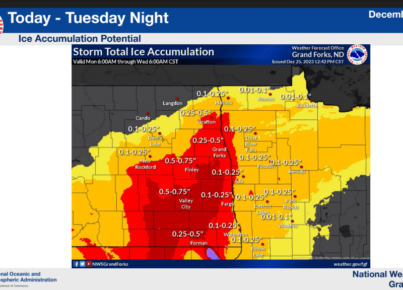
* WHAT…Significant icing is expected. Total ice accumulations up to one-half of an inch, with some areas receiving up to three-quarters of an inch. Winds gusting as high as 45 mph.

* WHERE…West Polk County and Eastern North Dakota

* WHEN…From 6 PM this evening to 6 PM CST Tuesday.

* IMPACTS…Power outages and tree damage are likely due to the ice. Travel could be nearly impossible. This will be a locally damaging icing event.

PRECAUTIONARY/PREPAREDNESS ACTIONS…
Travel is strongly discouraged. If you must travel, keep an extra flashlight, food, and water in your vehicle in case of an emergency. Prepare for possible power outages.

Share:
Tags: , ,