Skip to content
Customize Consent Preferences

We use cookies to help you navigate efficiently and perform certain functions. You will find detailed information about all cookies under each consent category below.

The cookies that are categorized as "Necessary" are stored on your browser as they are essential for enabling the basic functionalities of the site. ... 

Always Active

Necessary cookies are required to enable the basic features of this site, such as providing secure log-in or adjusting your consent preferences. These cookies do not store any personally identifiable data.

No cookies to display.

Functional cookies help perform certain functionalities like sharing the content of the website on social media platforms, collecting feedback, and other third-party features.

No cookies to display.

Analytical cookies are used to understand how visitors interact with the website. These cookies help provide information on metrics such as the number of visitors, bounce rate, traffic source, etc.

No cookies to display.

Performance cookies are used to understand and analyze the key performance indexes of the website which helps in delivering a better user experience for the visitors.

No cookies to display.

Advertisement cookies are used to provide visitors with customized advertisements based on the pages you visited previously and to analyze the effectiveness of the ad campaigns.

No cookies to display.

ADVERTISE WITH US | EMAIL: KROX@RRV.NET

MORE SNOW EXPECTED FOR RED RIVER VALLEY TONIGHT THROUGH FRIDAY

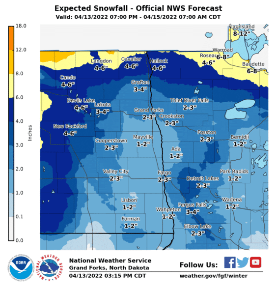
The National Weather Service is expecting all of northwest Minnesota and eastern North Dakota to get more snow starting after 7:00 p.m. Wednesday through Friday afternoon.  The highest snowfall totals will be along the Canadian border.  The snowfall information and map of expected snowfall totals are below.

-Heavy and intense snow has ended.
-Lull in winds and precipitation will end overnight. 
-Prolonged light snowfall along the international border is expected through Friday morning
-Increasing northwest winds with afternoon gusts up to 40 mph – highest in southeastern North Dakota
-Intermittent snow showers which will combine with wind and create occasional reduced visibilities down to a half-mile.
-Snow and rain will affect river levels, but to what degree is unknown at this time.

Share:
Tags: , , ,