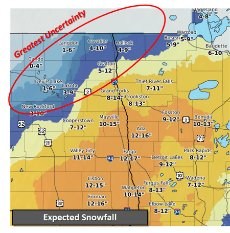
The National Weather Service in Grand Forks has issued a Winter Storm Warning in effect from noon on Saturday to 6:00 a.m. on Monday (December 30) for Northwest Minnesota and Eastern North Dakota, including the KROX listening area. The Warning includes the cities of Crookston, East Grand Forks, Thief River Falls, Red Lake Falls, Grand Forks, Cooperstown, Finley, Hope, Mayville, Hillsboro, Hatton, and Portland
* WHAT…Heavy mixed precipitation expected. Total snow accumulations of 8 to 16 inches and ice accumulations of up to one-tenth of an inch. Winds gusting as high as 50 mph.
* WHERE…Portions of northwest Minnesota and northeast and southeast North Dakota.
* IMPACTS…Travel could be very difficult to impossible. Widespread blowing snow could significantly reduce visibility on Sunday and lead to periodic whiteout conditions in open country.
The forecast for Crookston and the area over the next three days –
Saturday night – Snow. Patchy blowing snow after 3 am. Low around 26. Blustery, with a north northeast wind 7 to 12 mph increasing to 16 to 21 mph after midnight. Winds could gust as high as 30 mph. The chance of precipitation is 100%. New snow accumulation of 1 to 3 inches possible.
Sunday – Snow before 2 pm, then snow, possibly mixed with freezing drizzle. The snow could be heavy at times. Patchy blowing snow. High near 27. Blustery, with a north wind 21 to 26 mph, with gusts as high as 39 mph. The chance of precipitation is 100%. New ice accumulation of less than a 0.1 of an inch possible. New snow accumulation of 5 to 9 inches possible.
Sunday Night – Snow and freezing rain before 1 am, then freezing drizzle, possibly mixed with snow. Patchy blowing snow between 11 pm and midnight. Low around 19. Blustery, with a north wind 18 to 24 mph, with gusts as high as 37 mph. The chance of precipitation is 90%. New precipitation amounts of less than a tenth of an inch possible.
Monday – Snow and freezing drizzle before noon, then a chance of snow between noon and 4 pm, then a chance of snow and freezing drizzle after 4 pm. Patchy blowing snow after 9 am. High near 23. Blustery, with a north wind 20 to 22 mph, with gusts as high as 33 mph. The chance of precipitation is 80%. New precipitation amounts of less than a tenth of an inch possible.
Stay tuned to KROX Radio, KROXAM.com, and our social media for any updates.