THE NATIONAL WEATHER SERVICE HAS UPGRADED IT TO A STORM WARNING – CLICK HERE TO VIEW THE LATEST INFORMATION.
A Winter Storm Watch has been issued for northwest Minnesota and Eastern North Dakota from late Friday night to Saturday night.
The watch includes the counties of Polk, Kittson, Roseau, Lake of the Woods, Beltrami, Red Lake, Pennington, Clearwater, Towner, Cavalier, Pembina, Benson, Ramsey, Walsh, Nelson, and Grand Forks.
The watch includes the cities of Crookston, East Grand Forks, Hallock, Karlstad, Lancaster, Roseau, Warroad, Greenbush, Baudette, Warren, Stephen, Argyle, Newfolden, Middle River, Grygla, Red Lake, Redby, Ponemah, Thief River Falls, Red Lake Falls, Fosston, Fertile, McIntosh, Erskine, Bagley, Clearbrook, Bemidji, Cando, Langdon, Cavalier, Walhalla, Drayton, Pembina, Neche, St. Thomas, Fort Totten, Maddock, Leeds, Minnewaukan, Devils Lake, Grafton, Park River, Lakota, Mcville, Aneta, Tolna, Grand Forks, Edinburg, Adams, and Lankin
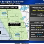
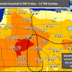
*WHAT…Heavy snow is possible. Total snow accumulations of 4 to 13 inches possible. Winds could gust as high as 40 mph.
*WHERE…Portions of north-central and northwest Minnesota and northeast North Dakota.
*WHEN…From late Friday night through late Saturday night.
*IMPACTS…Travel could be very difficult to impossible. Areas of blowing snow could significantly reduce visibility.
Stay tuned to KROX Radio and KROXAM.com for more information as the storm gets closer.