There are two weather systems that will bring snow today (Wednesday) through Saturday night to portions of northwest Minnesota and northeast North Dakota.
- The first of two rounds of accumulating snow begins Wednesdy afternoon into Thursday night. General 3-6 inches of accumulation will bring advisory impacts, currently forecast for areas along and south of Highway 200 from Cooperstown to Ada and in north central Minnesota.
- Round two of snow moves through Friday into Saturday. This system will be stronger than the first round, bringing 40 percent chance for warning level impacts from accumulating snowfall greater than 6 inches.
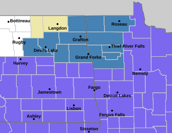
The National Weather Service has issued a Winter Storm Watch for portions of northwest Minnesota and north eastern North Dakota from Friday to Saturday night.
The watch includes Polk, Kittson, Roseau, Marshall, Pennington, Red Lake, Pembina, Benson, Ramsey, Walsh, Nelson, and Grand Forks counties. It included the cities of Crookston, Fosston, Roseau, East Grand Forks, Drayton, Hallock, Thief River Falls, Newfolden, Red Lake Falls, Devils Lake, Grand Forks, Grafton, Cavalier, Lankin, Middle River, and Warren.
…WINTER STORM WATCH IN EFFECT FROM FRIDAY AFTERNOON THROUGH LATE SATURDAY NIGHT…
* WHAT…Heavy snow possible. Total snow accumulations between 3 and 8 inches are possible. Winds could gust as high as 35 mph.
* WHERE…Portions of northwest Minnesota and northeast North Dakota.
* WHEN…From Friday afternoon through late Saturday night.
* IMPACTS…Travel could be very difficult. The hazardous conditions could impact the Friday evening commute.
The forecast for Crookston and the KROX listening area is below-
Tonight (Wednesday) – A chance of rain and snow before 1 am, then a chance of snow after 3 am. Mostly cloudy, with a steady temperature around 33. East southeast wind 11 to 14 mph. The chance of precipitation is 30%. New snow accumulation of less than a half inch is possible.
Thursday – Snow likely before 4pm, then snow, possibly mixed with rain. The snow could be heavy at times. High near 34. East wind 14 to 16 mph, with gusts as high as 26 mph. Chance of precipitation is 80%. New snow accumulation of 1 to 3 inches possible.
Thursday Night – Snow likely, possibly mixed with rain, becoming all snow after 10pm. Mostly cloudy, with a low around 27. Northeast wind 7 to 14 mph. Chance of precipitation is 70%. New precipitation amounts of less than a tenth of an inch possible.
Friday – A slight chance of snow before 1pm, then a chance of rain and snow. Mostly cloudy, with a high near 37. Northeast wind 8 to 13 mph. Chance of precipitation is 50%. New precipitation amounts of less than a tenth of an inch possible.
Friday Night – Snow, possibly mixed with rain, becoming all snow after 4am. The snow could be heavy at times. Low around 30. Northeast wind around 11 mph. Chance of precipitation is 90%. New precipitation amounts between a quarter and half of an inch possible.
Saturday – Snow, mainly before 1pm. High near 34. Breezy, with a north wind 14 to 22 mph. Chance of precipitation is 80%.
Saturday Night – Partly cloudy, with a low around 21. Blustery, with a north northwest wind 15 to 20 mph decreasing to 7 to 12 mph after midnight.
Sunday – A 20 percent chance of rain after 1pm. Mostly sunny, with a high near 40. West wind 6 to 15 mph.
 (2)")
 (3)")