UPDATED – 12/22 (4:06 p.m.)
The National Weather Service in Grand Forks has issued a Blizzard Warning for the KROX listening area from 3:00 to 9:00 a.m. Wednesday, December 23.
The warning includes the Minnesota cities of Crookston, East Grand Forks, Ada, Twin Valley, Halstad, Moorhead, Hallock, Karlstad, Lancaster, Warren, Stephen, Argyle, and Breckenridge.
It includes the following North Dakota cities – Cavalier, Walhalla, Drayton, Pembina, Neche, St. Thomas, Grafton, Park River, Grand Forks, Finley, Hope, Mayville, Hillsboro, Hatton, Portland, Valley City, Fargo, Lisbon, Enderlin, Gwinner, Milnor, Forman, Rutland, and Wahpeton.
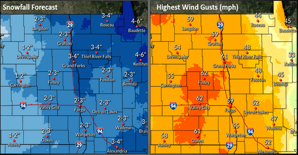
*WHAT…Blizzard conditions expected. Total snow accumulations of 2 to 4 inches on top of a light glaze of ice. Winds gusting as high as 65 mph.
*WHERE…Portions of northwest and west central Minnesota and northeast and southeast North Dakota.
*WHEN…From 3 AM to 9 PM CST Wednesday.
*IMPACTS…Plan on slippery road conditions. Widespread blowing snow could significantly reduce visibility. The hazardous conditions could impact the morning or evening commute. The dangerously cold wind chills as low as 35 below zero could cause frostbite on exposed skin in as little as 10 minutes.
*ADDITIONAL DETAILS…This event will occur during the Wednesday morning rush, and it also falls during a busy holiday travel period.
PRECAUTIONARY/PREPAREDNESS ACTIONS…Travel should be restricted to emergencies only. If you must travel, have a winter survival kit with you. If you get stranded, stay with your vehicle.
ORIGINAL STORY
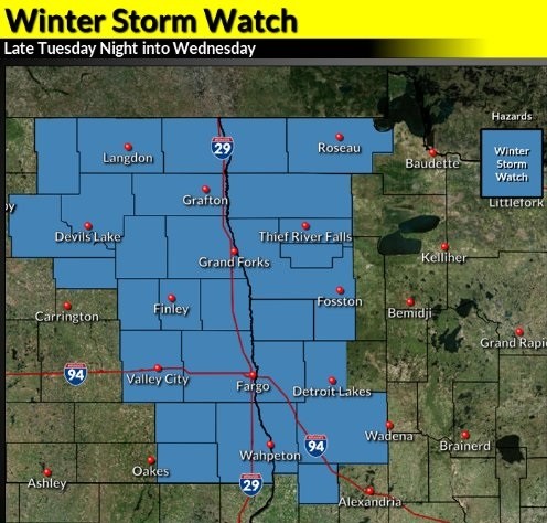
The National Weather Service in Grand Forks has issued a Winter Storm Watch for northwest Minnesota and eastern North Dakota from Tuesday night to Wednesday evening.
The watch includes the following Minnesota cities – Crookston, East Grand Forks, Ada, Twin Valley, Halstad, Moorhead, Hallock, Karlstad, Lancaster, Roseau, Warroad, Greenbush, Warren, Stephen, Argyle, Newfolden, Middle River, Grygla, Thief River Falls, Red Lake Falls, Fosston, Fertile, McIntosh, Erskine, Mahnomen, Naytahwaush, Waubun, Detroit Lakes, Breckenridge, Fergus Falls, Perham, New York Mills, Parkers Prairie, Henning, Battle Lake, Elbow Lake, Hoffman, Ashby, Herman, and Barrett.
It includes the following North Dakota cities – Grand Forks, Cavalier, Walhalla, Drayton, Pembina, Neche, St. Thomas, Grafton, Park River, Finley, Hope, Mayville, Hillsboro, Hatton, Portland, Valley City, Fargo, Lisbon, Enderlin, Gwinner, Milnor, Forman, Rutland, and Wahpeton.
*WHAT…Blizzard conditions are possible. Significant reduction to visibility will impact travel. Total accumulation 2 to 6 inches (highest toward NW Minnesota). Strong Northwest winds 50 to 60mph (high confidence). Wind chills falling to 20 to 35 below zero Wednesday. There is a potential for a little mixed precipitation at the onset before a full transition to snow. Blowing snow may linger into the afternoon hours on Wednesday after the main snow leaves the area.
*WHERE…Eastern North Dakota into portions of the northwest quarter of Minnesota.
*WHEN…From late tonight through Wednesday evening.
*IMPACTS…Plan on slippery road conditions. Widespread blowing snow could significantly reduce visibility. The dangerously cold wind chills as low as 35 below zero could cause frostbite on exposed skin in as little as 10 minutes.
*ADDITIONAL DETAILS…This event will occur during the Wednesday morning rush, and it also falls during a busy holiday travel period.
Stay tuned to KROX Radio and KROXAM.com for the latest updates on the storm.
Tags: