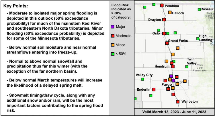
The National Weather Service in Grand Forks gave an outlook on the conditions through March 6 and forecast precipitation to Monday, March 13, and found there is a significant (moderate or higher) risk for spring flooding increasing with levels potentially rising to be near or above long-term historical averages across the Red River Basin.
According to a map of predicted flood points along the river from March 13 to June 11, there are several moderate to isolated major spring flooding for much of the mainstem Red River and southeastern North Dakota tributaries, with minor flooding for some of the Minnesota tributaries. The Service has found that below-normal soil moisture and near-normal streamflows are entering into freeze-up.
While we have seen normal to above-normal snowfall and precipitation thus far during the winter, below-normal March temperatures for the remainder of the month can delay the likelihood of a delayed spring melt. Snowmelt timing and the thaw cycle will be the most significant factors in if there will be a spring flood risk.
Stay tuned to KROX and kroxam.com for more updates on the weather with the National Weather Service in Grand Forks.
[embeddoc url=”https://kroxam.com/wp-content/uploads/2023/03/NWS-Grand-Forks-Spring-Flood-Outlook-March-9-2023.pdf”]
Tags: