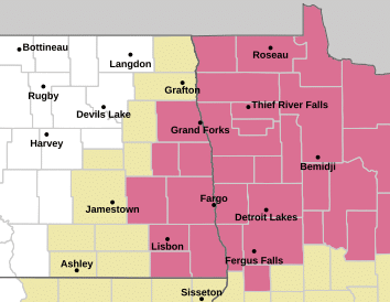
The National Weather Service in Grand Forks, North Dakota, has issued a Blizzard Warning for portions of northwest Minnesota and eastern North Dakota from 3:00 a.m. Sunday to 6:00 a.m. Monday.
The warning includes the following Minnesota counties: Polk, Norman, Clay, Kittson, Marshall, Wilkin, and Otter Tail. And the following North Dakota counties – Grant, Pembina, Walsh, Grand Forks, Steele, raill, Cass, and Richland.
The warning includes the cities of Crookston, Fargo, Warren, Grand Forks, Fergus Falls, Mayville, Wahpeton, Elbow Lake, Halstad, Grafton, Finley, Hallock, Hillsboro, Moorhead, Drayton, Ada, East Grand Forks, Cavalier, and Breckenridge.
…BLIZZARD WARNING IN EFFECT FROM 3 AM SUNDAY TO 6 AM CST MONDAY…
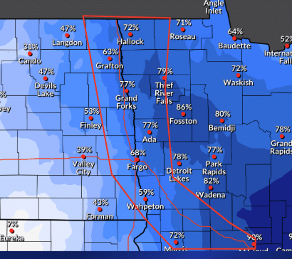
* WHAT...Blizzard conditions expected. Total snow accumulations between 3 and 5 inches and ice accumulations around a light glaze. Winds gusting as high as 50 mph.
* WHERE...Portions of northwest and west central Minnesota and northeast and southeast North Dakota.
* WHEN...From 3 AM Sunday to 6 AM CST Monday.
* IMPACTS...Travel will be very difficult. Whiteout conditions will make travel extremely dangerous or impossible. Gusty winds could bring down tree branches.
PRECAUTIONARY/PREPAREDNESS ACTIONS…
Travel should be restricted to emergencies only. If you must travel, have a winter survival kit with you. If you get stranded, stay with your vehicle. The latest road conditions for the state you are calling from can be obtained by calling 5 1 1.
.