East Polk County farmers are working land once consumed by gullies in the Upper Sand Hill River Watershed, where word spread fast about erosion fixes that kept topsoil in the fields and out of the Sand Hill River. The East Polk Soil & Water Conservation District program was so popular it required a waiting list. The 133 water and sediment control basins installed since 2011 keep 5,540 tons of sediment — the equivalent of 426 dump truck loads — and 4,120 pounds of algae-causing phosphorus out of the river each year. Stretches of the Upper Sand Hill are impaired for turbidity, E.coli, and low oxygen levels — which affect fish and recreation. But those reaches are close to meeting state water-quality standards.
The $1.58 million in East Polk SWCD projects drew from four Clean Water Fund grants totaling nearly $1.2 million, plus about $430,000 in matching funds from the Sand Hill Watershed District and landowners. Jim Hest, Red River Valley Conservation Service engineer, called the Upper Sand Hill Watershed projects the most successful work of his career. “Not only is it a win for the environment because we’ve done the sediment reduction — which also can be nutrient-loading to the receiving waters — but also the farmers really like these because it allows them to farm the land effectively,” Hest said. “They can farm it as a whole field now.”
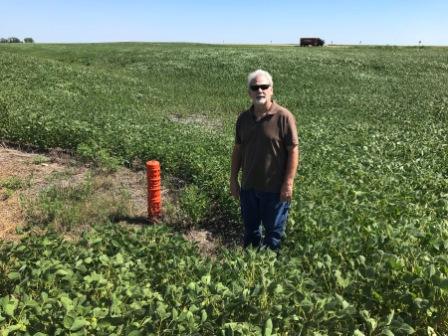
Hest explained how the structures work during an August field visit off Polk County Road 8 south of McIntosh with East Polk SWCD Manager Lisa Erickson and SWCD technician Rachael Klein. A nearly imperceptible seam in the wind-rippled rows indicated the draw that directs water to a 200-square-foot triangle of grass surrounding an orange filtration pipe. Hest designed the water and sediment control basin to retain runoff for up to 36 hours. Instead of carving new gullies, water is released slowly through an outlet. Sediment has time to settle. Crops grow where a gully once split the field. “The farmers in the past just dealt with them on a year-to-year basis and fixed them to where they could farm it from year to year,” Hest said. “(Now) it’s a once-in-every-10-year type of thing they’ve got to deal with.”
Eleven farmers are on the waiting list. “We didn’t have to sell the program. The program sold itself,” Hest said.
Bruce Grundyson was among the first to sign up. He took over the family farm in 1973, and now runs about 1,600 acres of soybeans and wheat. On 160 acres of rented land in King Township, for years he maneuvered around a washout deep enough to swallow farm machinery. “I couldn’t even work it anymore, it was so eroded,” Grundyson said. “I was having trouble getting to the other side to farm. It cut the field in two.” Hest designed the string of a half-dozen water and sediment control basins; Grundyson and the neighbor installed them. Grundyson said it was worth the cost and effort, even on rented land. “We don’t have the washouts anymore. I actually can cross the ditch,” Grundyson said. “It’s really improved the land, and we don’t have all that sediment running into the Sand Hill River.” From the field he rents south of McIntosh, water enters a county ditch that drains into the Sand Hill River. The river flows more than 100 miles from Sand Hill Lake south of Fosston to the Red River near Climax.
As an East Polk SWCD board supervisor, Grundyson has helped put even more erosion-control structures in the watershed. “We have people always inquiring because it is a cost-share program,” Grundyson said. Landowners pay 25 percent. Clean Water Funds cover 80 percent of the remaining balance; the Sand Hill Watershed District pays 20 percent. The projects align with the watershed district’s stewardship and its mission to manage water resources “in a manner which sustains and enhances the social, economic and natural resources.”
“It’s been working like crazy,” said Daniel Wilkens, watershed district administrator. “A little money goes a long way, and we’re actually getting something done on the ground that makes the world a better place.” East Polk SWCD staff expects 60 more water and sediment control basins to be installed using the 2016 infusion of Clean Water Funds it received from the Minnesota Board of Water and Soil Resources: A $790,240 targeted watershed grant. Since 2011, the Sand Hill Watershed District has contributed nearly $197,000 toward East Polk SWCD water and sediment control basin projects. “We’ve been able to work with landowners and fix the erosion problem,” Erickson said. “(Those fixes) not only benefit them — they benefit our water quality, which benefits the public and it benefits habitat.” Decreasing the sediment load should decrease turbidity, Erickson said, which should boost efforts to reintroduce fish and increase recreational use of the Sand Hill River.
Recreational use grows as crews clear snags-
Wayne Goeken has been paddling the Sand Hill River near his home in Fertile for years, both recreationally and as a River Explorers kayak trip leader. He’s continued to lead River Explorers’ student water-monitoring paddles since he retired two years ago as the International Water Institute’s special projects coordinator. Goeken started IRI’s River Watch, a citizen water-quality monitoring effort, in 1995 with four high schools in the Red River Basin. Data collected monthly from April through October include turbidity, dissolved oxygen, pH, water and air temperature.
Goeken led efforts to clear snags, which opened more river reaches to paddlers-
In early September, a Conservation Corps Minnesota & Iowa crew contracted through the Sand Hill River Watershed District started a 20-day snag-clearing job in Fertile. Moving west, they’ll clear downed trees, garbage, and other debris that cause roiling water to erode the banks.
The project was funded for its water quality benefits, but the crew’s work also will make paddling easier.
In the three years since volunteers started to remove downed trees, Goeken has noticed more kayaks atop vehicles in town, more vehicles parked at unofficial launch sites at road crossings.
He created a Sand Hill River paddling brochure mapping four segments totaling eight miles near Fertile. Nearly 200 people follow the Sand Hill River Kayaking page on Facebook. “It’s in the Glacial Lake Agassiz beach area, so it’s (got) steeper slopes. You do get a faster current,” Goeken said. “There’s a lot of waterfowl and deer through that area. It’s spring-fed through there, so usually there’s some base minimum flow that keeps it going.”
Goeken said he’d like to see the community view the Sand Hill River as an asset and become better stewards.
MAP LINK: Find an interactive paddling map on the Sand Hill River Watershed District’s website: https://bit.ly/SandHillRiverPaddling
 Jim Hest, conservation engineer with the Red River Valley Conservation Service, designed water and sediment control basins installed in East Polk County fields. In this soybean field south of McIntosh, only about 200 square feet of cropland is lost to the basin. The producer gained the ability to farm across a field once divided by a gully. Photo Credit: Ann Wessel, BWSR