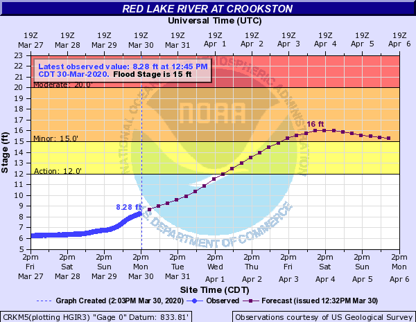
The National Weather Service in Grand Forks has issued a flood warning for the Red Lake River at Crookston that will go into effect Friday, April 3, at 10:00 p.m. The Red Lake River’s initial crest forecast is at 16 feet. Still, Jim Kaiser, lead forecaster with the NWS, said that crest doesn’t include this week’s forecasted precipitation, and a second crest is possible. “These river forecasts have the precipitation forecasts through Wednesday morning,” said Kaiser. “The bulk of our upcoming system is going to be in that Wednesday to Friday timeframe, so these forecasts do not include that rain or snow we see to the middle or end of this week. Possible second crest on these Minnesota tributaries as we see the meltwater from the higher elevations work into the system after this seven-day window.”
A current crest over the weekend shows minor flood stage with additional increases possible due to the precipitation. “Up at Crookston, we’ve seen a little bit of rise,” said Kaiser. “Looks like our current forecast hasn’t posted to the web. That was yesterday’s forecast. We’ll see flood level reached by the end of the weekend with the potential for further rises afterward based on the upstream snowmelt and precipitation for this week’s system.”
Even with the additional precipitation later this week, Kaiser said the forecast shows the river level staying below the moderate flood level in Crookston over the next 12 days. “Our forecast right now includes initial snowmelt and a little bit of the precipitation over the next two days, but does not include precipitation from the next system,” said Kaiser. “Precipitation from the next system could cause additional rises at Crookston in the 7-12-day window. I did chat with the River Forecast Center about Crookston this morning. It does cause an additional rise, more than the current rise, but it does stay below moderate levels at Crookston.”
A dry second half of winter has played a significant role in lowering the risk of heavy flooding since the initial outlooks in January said, Kaiser. “Our first outlook was sent at the end of January,” said Kaiser. “Since then, we have been very dry – low snowfall, low precipitation. Those outlooks we are issuing in January are using 60 years of February, March, and April’s – dry, normal and wet years – so, if we would’ve been normal since the middle to end of January these forecasts we’re looking at would be much higher than what we are looking at right now.”
The NWS also reminds residents in the flood warning to – turn around, don`t drown. Don`t travel through flooded areas. Most flood deaths occur in vehicles. People living in the Red River basin should monitor river levels while the river is in, or near, flood.
[embeddoc url=”https://kroxam.com/wp-content/uploads/2020/03/SituationReport_NWSGrandForks_Flooding_20200330_CJ.pdf” download=”all”]
Tags: