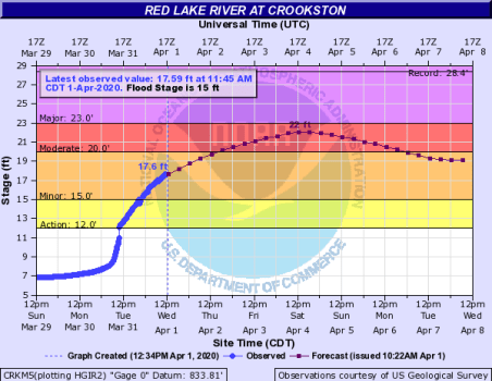
The National Weather Service in Grand Forks has released an updated river crest forecast for the Red Lake River in Crookston this weekend. The new crest is predicted at 22 feet Saturday evening into Sunday and represents a six-foot increase in the crest level from the forecast released on Monday.
Jim Kaiser, a lead forecaster for the NWS, said nights above freezing, ice, and the need to switch sensors as the water level increases have affected the crest prediction for Crookston. “We’ve had temperatures allowing for river levels to rise rapidly,” said Kaiser. “We’ve had those levels rise fairly rapidly which was expected given our temperature regime of days in the 40s, maybe even 50 degrees and nights above freezing. Also have ice issues at Crookston frequently causing fluctuations a little bit with how much water is actually in the system to what is ice, and also switched sensors a couple of times there.”
Temperatures will drop with the incoming storm adding about one inch of water to the Red Lake River Basin according to Kaiser. “Tomorrow’s highs are going to be in the 20s for much of the area, so we’re going to deal with more snow than rain for most of the basin,” said Kaiser. “How much liquid-equivalent is in that snow? This is where we see the rain, snow line showing about an inch or more from Fargo to Roseau.”
Kaiser said Crookston will have a second crest from the four to seven inches of snow expected during the incoming system outside of the current seven-day river forecast.
KROX is updating the Red Lake River levels hourly on our website by clicking HERE, or click on weather, then River Level readings.