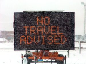
Skip to content
Customize Consent Preferences

We use cookies to help you navigate efficiently and perform certain functions. You will find detailed information about all cookies under each consent category below.

The cookies that are categorized as "Necessary" are stored on your browser as they are essential for enabling the basic functionalities of the site. ... 

Always Active

Necessary cookies are required to enable the basic features of this site, such as providing secure log-in or adjusting your consent preferences. These cookies do not store any personally identifiable data.

No cookies to display.

Functional cookies help perform certain functionalities like sharing the content of the website on social media platforms, collecting feedback, and other third-party features.

No cookies to display.

Analytical cookies are used to understand how visitors interact with the website. These cookies help provide information on metrics such as the number of visitors, bounce rate, traffic source, etc.

No cookies to display.

Performance cookies are used to understand and analyze the key performance indexes of the website which helps in delivering a better user experience for the visitors.

No cookies to display.

Advertisement cookies are used to provide visitors with customized advertisements based on the pages you visited previously and to analyze the effectiveness of the ad campaigns.

No cookies to display.

ADVERTISE WITH US | EMAIL: KROX@RRV.NET

Northwest Minnesota

news

SEVERE THUNDERSTORM WATCH ISSUED FOR NW MINNESOTA

The National Weather Service has issued a Severe Thunderstorm Watch until 3:00 a.m. on Tuesday, September 5, for the following counties in northwest Minnesota. Beltrami, Clay, Clearwater, Kittson, Lake of the Woods, Mahnomen, Marshall, Norman, Pennington, Polk, Red Lake, and Roseau.  A watch means conditions are right for the development of severe thunderstorms.

Share:
news

AIR QUALITY ALERT ISSUED FOR NW MINNESOTA BECAUSE OF CANADIAN WILDFIRE SMOKE

The National Weather Service has issued an Air Quality Alert in effect through 6:00 a.m. on Friday, May 19 for northwest Minnesota, including the cities of Bemidji, Crookston, East Grand Forks, Moorhead, and Roseau. WHAT…The Minnesota Pollution Control Agency has issued an Air Quality Alert for fine particle pollution. The Air Quality Index (AQI) is

Share:
news

MNDOT ENACTS NO TRAVEL ADVISORY IN MOST OF NW MINNESOTA

The Minnesota Department of Transportation (MnDOT) has enacted a no travel advisory on multiple highways in northwest Minnesota due to blizzard conditions. MnDOT snowplows continue to operate, but motorists are advised not to travel in these areas until conditions improve.   The picture below has the roads with no travel advised in purple. Motorists should plan

Share:
news

BLIZZARD WARNING CONTINUES TO MIDNIGHT, THEN WINTER WEATHER ADVISORY

The National Weather Service in Grand Forks, North Dakota is continuing the Blizzard Warning for northwest Minnesota and eastern North Dakota until midnight tonight and a Winter Weather Advisory from midnight until 1:00 p.m. on Sunday.   The warning and watch include the Minnesota cities of Crookston, East Grand Forks, Ada, Twin Valley, Halstad, Hallock,

Share:
news

BLIZZARD WARNING IN EFFECT TONIGHT THROUGH FRIDAY NIGHT -NO TRAVEL ADVISED

The National Weather Service in Grand Forks, North Dakota has issued a Blizzard Warning from 9:00 PM tonight to 6:00 p.m. on Friday to go with the Windchill Warning in effect until Noon on Saturday for northwest and west central Minnesota and eastern North Dakota. The warnings include the Minnesota cities of Crookston, East Grand

Share:
news

WINTER STORM WATCH UPDATED FOR NW MINNESOTA & EASTERN NORTH DAKOTA

The National Weather Service in Grand Forks, North Dakota, has moved up the Winter Storm Watch for northwest Minnesota and eastern North Dakota.   The watch will start at 6:00 p.m. Monday (December 12) and run through late Wednesday night. The watch includes the Minnesota cities of Crookston, East Grand Forks, Ada, Twin Valley, Halstad, Moorhead,

Share: