UPDATE 2-20 (11:00 a.m.)
The National Weather Service in Grand Forks, North Dakota Winter Weather Advisory issued for northwest Minnesota and eastern North Dakota remains in effect until 9:00 p.m. tonight (2-20).
* WHAT…Snow. Additional snow accumulations of up to two inches. Winds gusting to 40 mph.
* WHERE…Portions of central, north central, and northwest Minnesota and northeast and southeast North Dakota.
* IMPACTS…Plan on slippery travel conditions. Heavy snow rates and patchy blowing snow could significantly reduce visibility at times.
* ADDITIONAL DETAILS…The strongest winds and best chance for blowing snow will be this afternoon and evening after the snow ends.
PRECAUTIONARY/PREPAREDNESS ACTIONS… Slow down and use caution while traveling.
— — —
ORIGINAL STORY
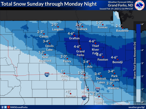
The National Weather Service in Grand Forks, North Dakota has issued a Winter Weather Advisory for portions of northwest Minnesota and eastern North Dakota starting at 6:00 p.m. Sunday to 9:00 p.m. on Monday.
The advisory includes the Minnesota cities of Crookston, East Grand Forks, Ada, Twin Valley, Halstad, Hallock, Karlstad, Lancaster, Roseau, Warroad, Greenbush, Warren, Stephen, Argyle, Newfolden, Middle River, Grygla, Thief River Falls, Red Lake Falls, Fosston, Fertile, McIntosh, and Erskine. The advisory also includes the North Dakota cities of Cavalier, Walhalla, Drayton, Pembina, Neche, St. Thomas, Grafton, Park River, Grand Forks, Cooperstown, Finley, Hope, Mayville, Hillsboro, Hatton, and Portland.
* WHAT…Snow and blowing snow. Total snow accumulations of 3 to 5 inches. Winds gusting as high as 35 mph.
* WHERE…Portions of northwest Minnesota and northeast and southeast North Dakota.
* WHEN…From 6 PM this evening to 9 PM CST Monday.
* IMPACTS…Plan on slippery road conditions. Heavy snow rates and patchy blowing snow could significantly reduce visibility at times. The hazardous conditions could impact the morning or evening commute.
* ADDITIONAL DETAILS…The strongest winds and best chance for blowing snow will be Monday afternoon and evening after the snow ends.