After a mild winter that saw minimal snowfall, spring arrived. Unfortunately, Minnesota residents will likely have their good fortune put on hold this weekend.
UPCOMING SNOWSTORM OVERVIEW
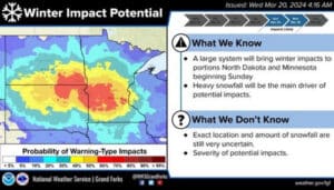
The Grand Forks National Weather Service has announced a potential snowstorm this weekend. The Weather Service shows that the storm will begin late on Saturday night or early Sunday morning and will last until early Monday morning or afternoon. The snow will start to fall in the western Dakotas first, reach eastern North Dakota by Sunday morning, and slowly work north throughout the day.
“Currently, in the Crookston area, there will be snow on Sunday,” said Grand Forks National Weather Service Meteorologist Blake Rafferty, “It should be on the lighter side as we get into the overnight hours; that’s when the heavier snow will begin. There is uncertainty about what will happen Monday morning, as the storm will take an eastward track. Snowfall totals will be lower, and snow will end on Monday.”
If the storm’s path heads further north, the Twin Cities will experience heavier snowfall on the southern edge of the storm. If the storm heads east, the Twin Cities will experience the brunt of the storm. “Either way, the Twin Cities will receive snowfall,” said Rafferty, “But the amounts (much like Crookston) in both cities are on different edges of the band. Crookston is on the northern edge, and Minneapolis is more on the southern edge.”
DRIVING HAZARDS FROM NORTHWEST MINNESOTA TO THE TWIN CITIES AREA
There could be potential road hazards during the storm, specifically late Sunday night and early Monday morning. Rafferty suggests all drivers heading to southern Minnesota over the weekend check the DOT map because heavy snow is expected to hit the area.
The Grand Forks National Weather Service shows West central Minnesota has an 80% chance of receiving six inches or more of snowfall over the weekend. Click here to view the MNDOT map and traveling suggestions over the weekend.
![]()