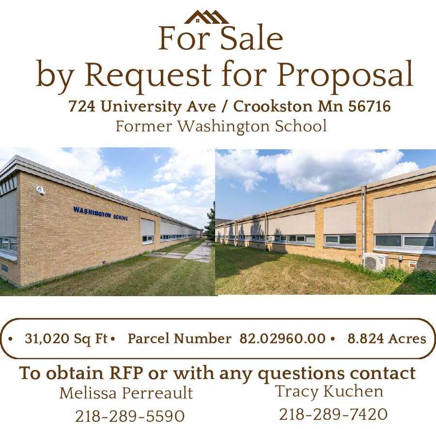
On Monday, a red flag warning was issued for much of Minnesota and North Dakota due to warm temperatures and high winds mixed with dry conditions that also contributed to a large grass fire in Polk County. Late last week the National Weather Service updated drought conditions across the Red River Valley including classifying Polk County’s drought condition as moderate.
Still, other areas across the valley are experiencing severe and even extreme drought conditions which could spread if dry weather persists. The current conditions are a far cry from the extremely wet conditions a year ago. “Normally, we’d be talking about flood this time of year,” said Gregory Gust, Warning Conditions Meteorologist with the National Weather Service. “But I that normally, but it’s flood to drought, drought to flood. We’ve had a number of years where we go from one to the other fairly quickly with a springtime flood to a summertime drought, or a drought in one part of the season back into a flood the next. It’s actually not that uncommon for us. But here we go, last fall, does anyone not remember how dry it was? Some areas were dry already in the late summer and it affecting crops. Most of the valley had a fair amount of rain through most of the summer and with residual soil moisture wasn’t doing too badly. But as you get into the fall months, we were of course pretty much dry all over. We started using up that residual moisture pretty well last fall and went into winter with way below normal snowpack. Early melt off with that this spring and we’re running half or less, in a lot of cases down to one-quarter of our normal precipitation from into spring here. Rivers are running but they are low, so we need rain.”
Most of northwestern Minnesota is currently experiencing moderate drought conditions with the western edges of Kittson and Marshall Counties. Gust explained the various drought conditions and the impact that could be seen from them. “Abnormally dry (D0) is when you’re missing that inch or so of rain and things are starting to dry up a little bit,” said Gust. “That’s where we were back and forth a lot of last summer on that type of thing. It’s generally a short-term precipitation deficit and not a lot. When you start getting into a moderate drought (D1), that’s when it’s last longer and you’re starting to get soil drying out. You’re starting to get some crop stress but still not losing a crop. D2 (Severe Drought) is crop and pasture losses. That’s where you’re starting to get the impact on your grasslands. Your fire danger is high, like today, and you have water shortages that are showing up. You could start getting into water restrictions in places that are drawing places from rivers or wells. At this point, I don’t think our wells are low, but you could start running into that eventually. Extreme Drought (D3), there are parts of North Dakota that are in that now for example. You look at the winter wheat crop, grasslands, and pasture lands that should be perking up over the last few weeks and they are really suffering now. It could start affecting the plant themselves and whether they’ll be able to produce.
While Polk County is several inches below normal precipitation already, Gust said that even a smaller significant rainfall could help get the spring started. “We’re kind of on that edgy D2 stuff,” said Gust. “And I’ll say it this way…the four or five inches of rainfall we’re behind now, we don’t have to catch up all four or five inches to pull out of this. A widespread half-inch, three-quarter inch, or 1-inch rainfall now, another one into the middle part of April would be great things. Those would do a lot to assuage mediary drought conditions and then, getting back into a normal precipitation realm. But we need to get some of those widespread rains to get in here and give us moisture. We might have enough to get a seed in and growing this spring but there is a lot of places that might not have that this spring but there is a lot of places that may not have that right now. So, that’s a big concern, getting that initial half or three-quarters of an inch that’s going to even get us into a start-able spring.”
The forecasted snowfall and precipitation this week aren’t going to amount to much, but the long-range forecast does show increasing chances for rain. “The stuff that’s going to come through this week is the type of thing that gives us a sprinkle, a teaser,” said Gust. “It’s not even going to be a dust settler in most areas, so we’re not counting on a lot this weekend. The good news is looking at the 8–14-day outlook. The 6-10-day still has us warm and dry. The 8-14-day is still showing warm but it’s starting to pick up on a little bit more chance of rain coming in for us in the latter part of that period. So, not that first week of April but maybe the second week. Getting into the three to four weeks, that tendency is there is going to be more precipitation that middle and latter part of April. So, that’s at least optimistic where the models are at least starting to show something that could turn into moisture for us. And we’ll need it desperately as we get into April. Hopefully, that second week of April we’ll start getting something that is measurable in a good way.”