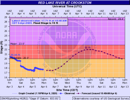
The National Weather Service in Grand Forks is predicting a second rise of the Red Lake River late this week with the model showing a crest between 7:00 a.m. and 7:00 p.m. on Friday, April 10 at 22 feet. Greg Gust with the National Weather Service said that crest will mostly contain local and upstream run-off from up around High Landing. “We are going to see some flow coming out of High Landing, pushing that up into action, maybe the low end of minor flood stage there,” said Gust. “And so, we’ll see increased flow overall on the Red Lake River. That again with local runoff should come into Crookston and we should see a secondary rise back up near 22 feet. We had the initial rise that came in just shy of that and we should see the secondary rise coming in. The good news is there should be nothing for additional river rise to worry about there.”
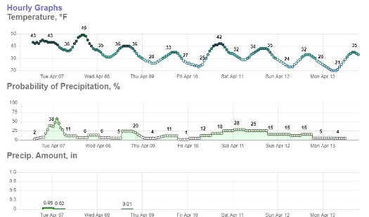
Gust said the new snow is expected to melt off fairly quickly throughout the week. “The current snow depths are dropping off fairly quickly,” said Gust. “We started off with 11 inches here in Grand Forks. We were down to three or four inches yesterday and losing. We did have a good measurement of the amount of moisture in a lot of places, certainly that early freezing way and a pretty good estimate on the snow cover. We think we have that put into the model, of course, the trick is how is that going to come off. So, we think we have a pretty good estimation of the overall moisture content from this last storm.
The good news is there isn’t a risk for additional ice jams like was seen during the initial rise as most of the ice has broken up all the way down to East Grand Forks said, Gust. “That drop that occurred on Saturday was the ice downstream letting loose in places,” said Gust. “I think the ice was both that first peak we saw in there and the drop-off was ice letting loose downstream in places, first between Crookston and Fisher and then between Fisher and East Grand Forks.”
Over the weekend many of the river sensors throughout the basin went offline due to ice build-up from the winter storm. Gust said that between technicians clearing ice from the sensors and the sun melting it most of those sensors, including Crookston, are operational sending out signals again. “One thing you may have noticed is that we had a lot of the river gauges that dropped off during that storm and there are still a couple that are just coming on this morning,” said Gust. “There was a lot of the ice with that storm that built upon antennas that are used to communicate with some of those river sensors. Over the weekend the U.S. Geological Survey, Minnesota DNR, and other technicians were out there checking on those, making sure they were working and in good shape, but mostly it was the sun warming up getting the ice off the antennas.”
Gust added that forecast for the next couple of weeks looks to be cool and wet, but that as we get into late April things appear to get dryer while remaining relatively cool. “Cool and wet is the main descriptor here through the middle part of April,” said Gust. “The very end of April into the beginning of May showing cooler but starting to get into a dryer pattern. We’ll see if that holds true.”
There are two systems expected to move through the Crookston area this week with minimal moisture. The model below shows .06 of an inch Tuesday into Wednesday with an additional .01 of an inch Thursday.