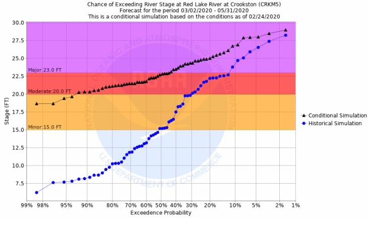
A dryer than typical February has softened the river crest predictions across the Red River Basin. The Red Lake River in Crookston is now forecast to crest around 22.8 feet, a significant decrease from the January forecast to exceed 24 feet.
Gregory Gust, a meteorologist with the National Weather Service in Grand Forks, said that the 50 percent point, the most likely flood level with average precipitation, in Crookston is just below the major flood stage. However, the Red Lake River still shows above major flood stage between Crookston and Grand Forks. “The 50 percent point is just sitting in the moderate, just ducked below the major flood stage,” said Gust. “That’s up at 22, pushing 23 feet. So, again, you’ll see some park flooding in Crookston as well as the possibility of paying attention to those levies and having some dike patrols. From that point, the Red Lake River from Crookston into Grand Forks, you’re going to see that area of major flooding throughout the Red Lake River system as you get closer to Grand Forks. You’re going to have backwater and going to have a fair amount of spread.”
Above-average runoff is still expected throughout the region, including southwestern Polk County, which could be at or higher than the 2019 runoff explained Gust. “We still have a significant flow as well coming out of the southwest part of Polk County,” said Gust. “We have lowered the overall flood outlook for Shelly down in Norman County. Moving up toward Climax, it’s sitting very similar, having gone down just a little bit, but we’re still going to see a significant amount of flow. So, something similar to what we saw in 2019 is on the table, maybe even a bit worse.”
The decrease in the model prediction is unusual according to Gust, and one reason was a change in the model that allowed the January forecast to look later into spring, similar to what the late February outlook includes. “If you’ve noticed from January 23 to this February outlook, we are ratcheting down the outlook slightly,” said Gust. “Historically, when we’ve done these, January started lower and through February into March, we’ve increased the level. A lot of that was due to the length of the window we were allowed to look through. In the January outlook, some changes to the River Forecast Center increased the length of the window we were allowed to look through to mid-May, which picks up some of the later and larger flood crests to make the January data better match what we’d see in February outlooks. January came out very strong as a result. In previous years it would’ve probably been a much weaker and lower start.”
Snowfall in the northern basin over the past month has been about .65 inches below normal since January 18, which is the good news, but Gust said there is not a clear signal toward either a dry, wet, or normal spring precipitation. “Back into the review, good news, flood risk categories are down slightly pretty much all over the place,” said Gust. “Again, the snowfall and snow water content since January 18 is running below normal, so that’s helped us out. Along with our mild conditions, which are still keeping us with a relatively shallow frost depth. Bad news, of course, is we still have that risk for significant flooding charged by very wet ground conditions underneath the snow. And the fact that we are still dealing with above-average snowpack and snow water content. Our latest climate outlooks do not show a clear signal towards dry, wet, or even normal, so that’s an outlier out there, and of course, we know March can be highly variable. This spring, the risk levels are still looking at Top 10, possibly even into Top 5 flood territory.”
According to Gust widespread runoff, road closures and floodwall closures are still expected. “We would expect to see widespread runoff across the basin, road closures, floodwalls closed,” said Gust. “Possibly worse than the spring flood of 2019 and possibly into Top 10 flood category. At this point, we have a lot less winter to go through and a lot of early spring to play out, so stay tuned.”
[embeddoc url=”https://kroxam.com/wp-content/uploads/2020/02/RRN_and-DVL_FebruaryDiscussion_27Feb2020-1.pdf” download=”all”]
Tags: